










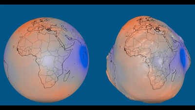
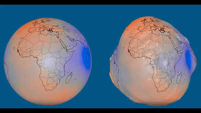
We’ve all grown up learning that the Earth is a smooth blue marble floating in space.But if you might have caught your eye on NASA’s latest adaptation model of the blue planet, it looks more or less like a potato!Sounds bizarre, right?But the image isn’t a mistake, and it isn’t showing you what Earth actually looks like either. It’s is the geoid, a model of how Earth’s gravity would shape a global ocean if no tides, wind or currents got in the way. According to NASA, since gravity doesn’t pull with the same strength everywhere on the planet, that imaginary ocean surface would rise in some places and dip in others.NASA exaggerated those differences by 10,000 times to make them visible at all, and the result is the strange, bumpy shape that’s been going viral.
What is the geoid?
The geoid is a mathematical model of Earth’s gravitational field, not a picture of the planet’s real surface. It represents what the sea level would be like across the entire globe, including under the continents, if oceans were shaped purely by gravity and Earth’s rotation, with no waves, winds or currents involved. It’s just like a reference tool scientists use to measure gravity’s uneven pull, rather than an exact photo of how the Earth looks from space.
Why gravity does not work the same everywhere
Gravity might feel constant, but it isn’t. Mass is spread unevenly across and within Earth, so its gravitational pull varies from place to place too. Mountains, ocean trenches, and differences in the density of rock beneath the surface all nudge gravity up or down. Where there’s extra mass, water is pulled slightly toward it, creating a rise in the geoid; where there’s less, the theoretical sea level dips instead.
Where gravity is strongest and weakest
The geoid’s extremes sit at opposite ends of the globe. Around Iceland, it rises about 85 metres above the reference level, a smooth, standardised model of Earth used as a baseline. South of India, the geoid dips around 106 metres below that same reference level, marking the lowest point in Earth’s entire gravity field.
How was this model built?
The visualisation is made by more than a billion measurements gathered by 19 satellites over 15 years, including NASA’s GRACE mission and the European Space Agency’s GOCE satellite. That data feeds into the GOCO06s gravity field model, which researchers use to track how Earth’s gravity changes as ice, water, and other mass move around the planet; that’s also valuable for mapping, surveying, and navigation.