



![‘The Paradise’ box office collection day 3 [LIVE]: Nani’s film shows steady growth on Saturday, nears Rs 80 crore India gross | Telugu Movie News](https://usnewsflash.online/wp-content/uploads/2026/09/the-paradise-day-3-150x150.jpg "‘The Paradise’ box office collection day 3 [LIVE]: Nani’s film shows steady growth on Saturday, nears Rs 80 crore India gross | Telugu Movie News")





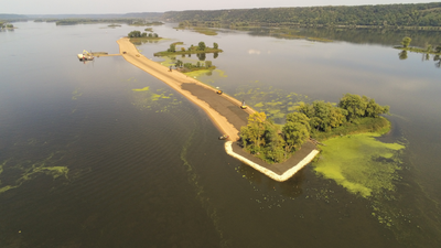
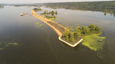
Islands and backwaters along the Mississippi River near Guttenberg, Iowa, have been gradually disappearing as erosion, flooding, wind and waves wear away their shorelines. Now, a major habitat restoration effort is rebuilding some of those lost features. The Lower Pool 10 Habitat Rehabilitation and Enhancement Project, part of the U.S. Army Corps of Engineers’ Upper Mississippi River Restoration Program, is using dredged river material to create and reinforce islands while improving nearby aquatic habitat. According to the Corps’ project, the plan is designed to protect and restore about 630 acres of riverine, backwater and floodplain habitat.
Why the Mississippi River islands are disappearing
The restoration is taking place in Lower Pool 10, on the Iowa side of the Mississippi River navigation channel, about a mile upstream from Lock and Dam 10 in Guttenberg. The area is part of the Upper Mississippi River National Wildlife and Fish Refuge and includes a complex of islands and side channels. Over time, natural islands in this part of the river have been worn down by wave action and flows from the main channel. Flood events have added to the pressure. According to the Corps, erosion has reduced wetlands and removed aquatic vegetation and shallow, protected areas that provide important habitat for fish and wildlife.River currents, boat traffic and flood events have contributed to the erosion. As islands disappear, backwater areas can become more exposed and sediment can accumulate in places that once provided valuable habitat. The problem is not simply about losing pieces of land. Islands help shape the movement of water through the river system. They can shelter backwaters from strong currents and waves, creating calmer and shallower areas where aquatic plants and wildlife can thrive.
How dredged river material is being reused
One of the notable aspects of the project is that material removed from the river during navigation dredging is being put to use in the restoration. According to the Corps, the project will beneficially use nearly 300,000 cubic yards of sand dredged for Mississippi River navigation to build island foundations. Instead of treating the dredged material only as something that needs to be placed elsewhere, the project incorporates it into the habitat restoration itself. The crews are using construction equipment, including skid loaders and bulldozers, to work on the islands. The sand being used comes from the bottom of the Mississippi River and had previously been dredged to maintain sufficient depth for barges.The project’s technical documents provide more detail on how the new islands are being built. Granular material, primarily sand, forms the base, while finer material is placed over it. Rock protection is also being installed around existing islands to help prevent further erosion. Rock sills and mounds are planned in selected locations to reduce wave and wind forces and influence water flows into backwater areas.
What the restoration will change
The selected plan combines several types of work rather than simply creating new islands. It includes constructing new islands, protecting existing shorelines, building rock mounds and sills, and dredging habitat areas. Together, these measures are intended to improve the quality and stability of the river environment. The project is designed to benefit about 630 acres within the project area. The Corps’ review documents specifically describe the acreage as riverine, backwater and floodplain habitat. They also say dredged material from backwater areas will be used to restore islands and create deeper-water habitat that can provide benefits for fish.The wider project site itself is a roughly 1,000-acre side-channel and island complex, meaning the 630-acre figure refers to the habitat expected to benefit from the selected restoration plan rather than the entire physical site.
A project being built in stages
The restoration is not a single construction operation. It is being delivered in stages across different island and backwater complexes. Stage 1 focuses on the southern islands in South Ferry Slough. The Corps awarded a $7.5 million construction contract for that stage in 2024, and construction began in 2025. Stage 3 focuses on the McMillan Island complex between river miles 618 and 619. In May 2026, the Corps awarded a $5.5 million contract for this stage, which includes island creation, shoreline protection, main-channel dredging and dredging of overwintering backwater areas. Construction was expected to begin in summer 2026 and continue into late 2027. The Corps currently lists the project’s anticipated construction cost at $39.5 million. The project is expected to be completed in 2030, although construction of remaining stages depends on available appropriations.
Why the restored habitat matters
The goal extends beyond rebuilding visible islands. Restoring the islands can help recreate the sheltered conditions associated with wetlands, shallow water and backwaters. These environments provide space for aquatic vegetation and offer habitat for fish and other wildlife. The Corps says the project is intended to improve ecosystem health and create better-quality habitat for native and desirable species. The work is part of the broader Upper Mississippi River Restoration Program, a federal programme authorised in 1986. The programme combines habitat restoration with long-term monitoring of the river system. According to the Corps, more than 62 habitat projects benefiting approximately 120,000 acres have been completed throughout the programme’s history.For the Lower Pool 10 project, the approach is therefore both restorative and preventative: rebuild islands that have already been lost or severely eroded, while strengthening existing features so they can better withstand the forces that caused the damage in the first place. The use of dredged sand also connects river navigation with habitat restoration, giving material removed to maintain the navigation channel another purpose within the river ecosystem.